
I have been reading Winston Churchill’s memoirs of WW2. Among many things I did not know is shown by his [WSC’s] great grasp of the names of land and sea as distinguished from its political label. Picking an easy example, Iberia is what we call Spain and Portugal when we view that land without knowing it is two countries. So I thought I’d write a bit about names we could have learned at school, perhaps did, and some of which will have been missed.
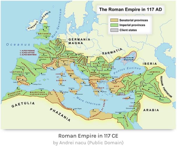
For example, when writing about the desert war, WSC refers repeatedly to Cyrenaica. Similarly, he refers to Dacia when writing about Hitler’s move towards Russia. Okay, he is showing signs of a classical education, but we were not all blessed with such advantages. A map of the Roman Empire will help.¹
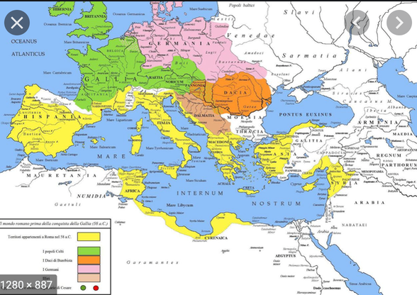
Cyrenaica is that headland of modern Libya east of the gulf of Syrtis (that yellow coast labelled Africa, left). In the left corner of that Gulf is Tunisia. Immediately to the west of it is Numidia, with ancient Carthage by the first R in Mediterranean (again, left). Mauritania was then far larger than now. Tripolitania, that WSC refers to often, is that part of Lybia (Libya) immediately east of Tunisia, the RICA of Africa.
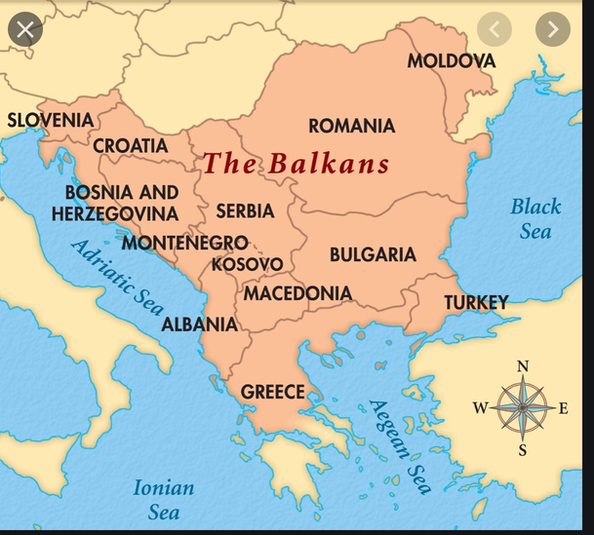
The Balkans is the whole huge peninsula between the Adriatic and the Black Seas.
At the top is a modern map of the region, where now, politically, we probably exclude Greece and western Turkey (Thrace would be a better label). There are fascinating maps showing the changes across the centuries. If interested, I suggest you start by simply Googling balkans maps, or looking at this animation. Looking at that last caused me to discover (new to me, I mean) the (seven, in principle) Ionian islands, the Heptanese; these were owned by Britain 1809-1862. initial ownership followed from the Treaty of Paris, 1815 at the end of Napoleon’s adventures. Britain handed the lot to Greece, though keeping the port of Corfu, where Prince Philip² was born.
Here's a Roman Empire map showing Dacia.
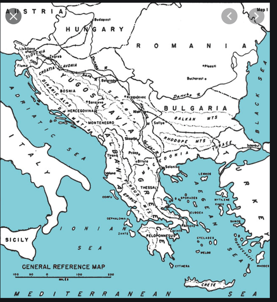
In blue and white, is a general map from WW2: areas that may be new to you would be the mountains (Balkans, Rhodope, Pindus, Dinaric) and you might notice Dalmatia, that long stretch of the Adriatic coast. For comparison, the modern Balkans, 2012 version, is at the top. ³
Sticking with the Med, I remember listing seas of the world while at Shiplake and finding 11 within the basin: Adriatic, Aegean, Alboran (between Algeria and Spain), Balearic (between the Balearics and France/Spain coast), Sea of Crete (north of Crete, south of the Adriatic), Ionian, Levantine (eastern Med, Cyprus within it), Ligurian (north of Corsica), Sea of Sardinia (west of the island), Thracian, Tyrrhenian. Within the Aegean are also the Icarian (the SE part of the Aegean), the Myrtoan (between the Cyclades and the Pelopennese) and the Thracian (the northern end). Add in the Black Sea, Seas of Azov and Marmara and you have 17, with the Med itself, 18. To make twenty we might include the Libyan Sea, from the Levantine westwards, and the Cilician Sea, NW of Cyprus. I think I might argue that there are nineteen, with the Mediterranean as number zero. Quiz yourself here.⁴ Adding to your vague grasp of names around here, Gallipoli is the spit of Thrace pointing SW at Limnos and the Crimea is that near-island on the north of the Black Sea.
Can you name the countries around the Baltic? Try for ten. Answers in footnote ⁵.
A sea is, at heart a basin of the sea floor. Generally these cause weather changes, noticed most by sailors, who historically do not stray far from land. Thus names attach to the margins of seas.
What about the seas of the Pacific? Here’s a list in alpha-order so you can see which you know: Bering, Bismark, Bohol, Celebes, Coral, East China, Japan, Okhotsk, Philippine, South China, Sulu, Tasman, Yellow. You may add the Salish Sea, the sea of Chiloé.⁶ Including some overlap with that list, here are the seas from IndoChina to NewZealand (is that Oceania?): Andaman, Arafura, Banda, Bismark, Bohol, Celebes, Ceram, Coral, Flores, Halmahera, Molucca, Savu, Solomon, Sulu, Tasman, Timor, Visayan; mostly known (not H & V for me) but omitted. The Bismark Sea and the New Britain Is sound cold but are not. The Philippines archipelago adds the Samar, Camotes, Bakor and Luzon; the Bohol is also called the Mindanao. Similarly Japan adds several names (-nada) not on many maps - Amakusa-nada, Ariake Sea Hibiki-nada, Seto-nada, Hibiki-nada, Hiuchi-nada, Hyuga-nada, Iyo-nada, Uwa (nada?), Inland Sea, Suo-nada, Sumo-nada, Aki-nada, Bingo-nada, Harima-nada, mostly between Fukuoka (W) and Osaka (E). Try itouchmap.com.
Seas of the Atlantic(s): Baltic, Black, Mediterranean, North, Scotia, Norwegian, Labrador, Caribbean, Sargasso - and the tributary seas such as the Irish, Celtic, Greenland. Two I didn’t know are the Malin (as from the shipping forecast, Malin and parts of Rockall, so that chunk of sea with the western isles of Scotland out to Rockall the island) and the Iroise (that patch of water between the Celtic sea and the Bay of Biscay; Brittany, basically.
If you want to learn the names of the seas, you have to include the ones around the Antarctic. Picking up from the Scotia sea at ten o’clock we have these: Weddell, Lazarov, Riiser-Larsen, Cosmonauts, Cooperation, Davis, Mawson, D’Urville, Somov, Ross, Amundsen and Bellingshausen. I knew only six of these. In terms of politics, since the continent is divided radially, one might describe the Weddell as British (or Argentine and Chilean), the Ross as belonging to New Zealand, Lazarov to Norway, all those on the right to Australia (but for a smidgen to France) and the Amundsen as unclaimed (which is silly when there’s the Weddell Sea under dispute, but the Antarctic Treaty System governs the division). Basically it (ownership, responsibility, claim) depends who owns the land / islands to the north.
You tell me of substantial places you didn’t know & not included, and I’ll add them to this.
DJS 20150305
I tried googling Apolitical Geography and got the opposite.
The Red Sea escaped attention. In English this is the long narrow stretch between Africa and the Arabian peninsula, but the name used to apply far wider, to an area south of the Sinai peninsula and stretching to the Indian Ocean. We now call this the Arabian Sa or, less often, the Erythraean Sea.
Churchill’s references may come from him having had a classical education. They might equally be based on the particular maps he had available in 1940 (I doubt they changed much once his team started using them) In his WW2 set of six books he refers to places he assumes the reader can locate without reference (and remember this in days before Google, so because looking things up took a long time, we actually knew a lot more facts). Here are some examples of his assumed geographical knowledge:
Cotentin, which I know as the Cherbourg peninsula
Istria, the biggest peninsula in the Adriatic, is a downward-pointing triangle at the northern end
the British Sea (the Channel); the Laccadive Sea (west side of Sri Lanka).
The Aland (sometimes Alands) at the southern end of the Gulf of Bothnia inside the Baltic;
The Koro Sea is immediately to the east of Fiji.
Unknown to me and references found and eventually traced: Somov Sea [ a proposed Russian name for the bit of sea between the Ross Sea and D’Urville sea in Antarctica]; MeiYu Yang (“no fish ocean” in Chinese), off NingBo (across the bay from Shanghai); and Maotou Yang (“cat head pond”? says the boss) a little further south still, towards Taizhou.
Some things are not called seas but probably should, such as the Gulf of Mexico, the Bay of Bengal, Hudson Bay,
Along the edges of the Arctic (not Artic) are, in clockwise order: Greenland (Norwegian south of that), Barents, White Sea (Russian coast), Pechora (ditto), Kara, Laptev, East Siberian, Chuchki, (Bering to south of Bering Strait), Beaufort (north of Alaska and across northern Canada, where what would be seas in the med are all called bays); to this we can add the Lincoln between Canada and Greenland; the Wandel or McKinley from NE Greenland to Svalbard. the Queen Victoria runs from Svalbard to the east. I note that Google Earth does not name the seas of the coast of the Antarctic.
All the maps disappeared some time in 2020 and I restored maps once I'd noticed. That may make some of the references incorrect, for which I apologise (which is less work than try to fix them all).
1 Map of the Roman Empire at its Greatest Extant (sic, incorrect spelling). I prefer the wags version, the ‘wholly roman empire’, much of which we could aspire to again.
2 Yes, the Duke of Edinburgh, Prince Philip of Greece and Denmark, Philippos Mountbatten (perhaps; I’m stretching a point or two. Names of royalty is always confusing in usage. Look him up yourself). .
3 This map shows something of the ethnicity and goes quite a way to explaining the long-running unrest in the region.
This link gives you the best general map of the Mediterranean I have found. You may need to nudge it into loading.
4 Boring, I got all 12 right.
http://en.academic.ru/pictures/enwiki/77/
Map_of_the_Mediterranean_and_subdivisions.svg gets you the better quality version of this simple helpful map. I confess to not recognising the Alborean Sea.
5 Baltic: clockwise. Sweden, Finland, Russia, Estonia, Latvia, Lithuania, Kaliningrad, Poland, Germany, Denmark. Baltic States spell ELLi going south. The White Sea canal in the north and the Kiel canal in the south avoid the Kattegat. Three Gulfs; Bothnia, Finland and Riga. Got it? Kaliningrad is on the Bay of Gdansk and used to be called Königsberg when it was Prussian. The port [Baltiisk] is ice-free all year and so pretty special. The enclave is separated from Russia (no common border, hence an enclave) and there are special arrangements for movement of people to the rest of Russia (and back). The other bit of Russia, headed by St Petersburg has the White canal, which connects the Gulf of Finland up the Neva river to Lake Ladoga, then up the Svir to Lake Onega; the 48km of real canal (as opposed to canalised rivers) connects to Lake Vygozero which then runs into the White Sea and on to Archangel. It’s not very deep and it takes light traffic, 10-40 boats a day, says wikipedia. If you didn’t realise, it is possible to go from Lake Onega to the Volga, hence to Moscow and (or) the Black Sea; hence, from the White to the Black by water. Patrick Robinson wrote about this and submarines [maybe in Kilo Class]
6 The Salish Sea is the water between Vancouver and Seattle; I wondered if it should be (or was once) salt-ish.
The sea of Chiloé is (small, and) behind the island(s) of Chiloé, unsurprisingly belonging to Chile, where the coast starts breaking up in the south.