Unlearned geography: Peninsulas of the world.
Following on from Essay 154, which was mostly about seas, I thought we ought to look at peninsulas. In 154 I mentioned Iberia and with that we can join the obvious (large) peninsulas around the world: Southern India, Scandinavia, Alaska, Arabia and perhaps Labrador. Politically these are much the same and so not a problem.
Challenge: can you place these? Your test is to point to them on Google Earth, starting from the whole planet in view, though the software won’t show you the names. Open another window and have a go; they’re in three groups in order of perceived difficulty, though you may disagree – I suspect this sort of knowledge is highly personal.
Jutland; Anatolia; Yucatan; Shandong; Cape York; Kamchatcka; the Wirral; the Gower; too easy, the Antarctic peninsula
the Crimea; the Kola; Liaodong; Westfjord; the Delmarva; the Rhins;
Salentino; Ungava; Giens; Valdes; Gallipoli; Gaspé, Istria.
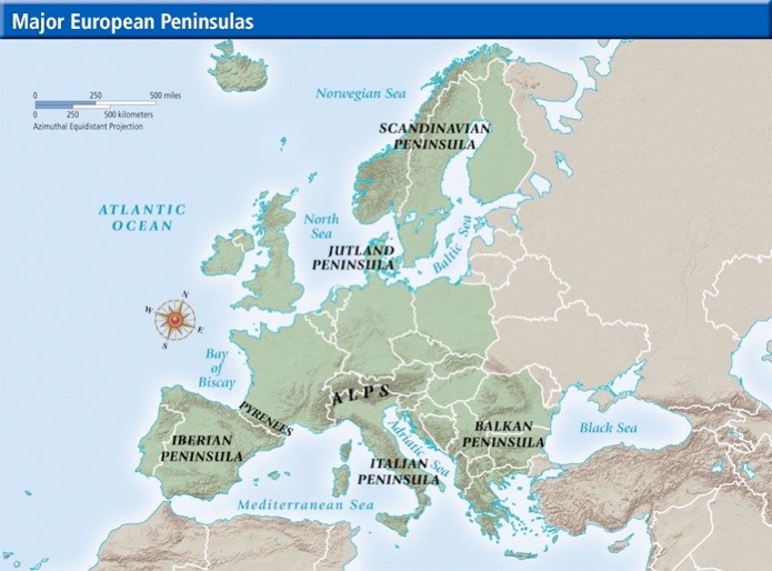
Let’s be a bit more selective. Start with Europe. To those shown I add:
the Crimea (the land pushing into the Black Sea so it looks like Australia).
the Kola is that snout facing east above the White sea, NE of Finland.
Jutland is sometimes called the Cimbrian peninsula.
Turkey’s Asian portion is named the Anatolian peninsula, similarly Brittany is the spike of France in its NW corner. The Italian might be better named the Apennine. I failed to find good names for the toe (Calabrian?) and heel of Italy (Gallipoli? Taranto? Wrong; Salentino). Gallipoli is that thin NE-SW slice of land closing the Sea of Marmara WSW of Istanbul. In France, what you think of as the Cherbourg peninsula is properly the Cotentin, to the east of Brittany. There are some small ones, such as around Vannes / Quiberon, in southern Brittany where the gulf of Morbinan is protected to the south by the Rhuys peninsula (Presqu’ile de Rhuys) and on the west by the Quiberon peninsula. The Medoc is the peninsula protecting the Gironde estuary. Since this is the estuary for the Garonne river, you may be confused to learn that the Garonne estuary is on Vesta, an extrasolar colony in the asteroid belt. Play with Google, I suggest. I put the Hyeres above in the hard group; it may be called the Giens peninsula, near or even within Toulon. There’s a wedge of modern Croatia pointing south into the Adriatic; this is Istria (sometimes, confusingly, Istra). I noted adjacent islands called Cres, Rab and Krk.
In Britain you may or may not recognise these: Ards Peninsula; Island Magee, Lecale peninsula, Ramore Head (Portrush);
Ardnamurchan Lochaber, The Black Isle Ross & Cromarty, Cowal Argyll and Bute, Doonie Point Aberdeenshire, Dunnet Head Caithness, Faraid Head Sutherland, Easter Ross (Highland), Fife, Kintyre Argyll and Bute, Knoydart Lochaber, The Machars Dumfries and Galloway, Morvern Lochaber, Strathy Point Sutherland, Point of Hellia Orkney, Point or the Eye peninsula Western Isles, Rhins of Galloway the Rhins;
Gower Peninsula, Gower, Llŷn Peninsula (Gwynedd), Creuddyn Peninsula juts out of the North Wales coast at Conwy, Gower Peninsula Swansea (Essay 145), Pembrokeshire peninsula, West Wales includes the South Pembrokeshire Peninsula which has as the S Wales limit of the Irish sea, St Davids Head, and the Marloes Peninsula, west of Milford Haven. Sometimes this whole headland is simply called South West Wales from Swansea to New Quay;
South West Peninsula (Cornwall, Devon, Somerset, and Dorset), Dengie peninsula (Essex), Furness (Lancs), The Fylde (Lancs), Hoo (Kent), Isle of Dogs (London), Greenwich Peninsula (London), Gosport, (Hants), The Lizard, (Cornwall), Manhood Peninsula (West Sussex), Morte Point (North Devon), Penwith (Cornwall), Isle of Purbeck (Dorset), Isle of Portland (Dorset), Rotherhithe (London), Spurn (East Yorks), Shotley peninsula (Suffolk), Tendring (Essex), the Wirral, Merseyside. [source, largely]
That little bit of Cyprus that points as if it fits into the NE coastline is the Karpasia peninsula. If you know the island you’ll expect me to also name the spits at Akrotiri, Akamas and Karucam. Can you name the bay that the Karpasia points at?¹ Which sea is this?²
The southern edge of Gdansk’s home bay is a sandspit known as the Hel peninsula, some 35km long. Similarly, the Troia peninsula is opposite Setubal in Portugal (I lived there in 1978). Wikipedia refers also to the Setubal peninsula, which is, I think, the land next north, between the river Sado and the Tagus [Tajo] (Setubal to Lisbon). Exercise: Find more similar sandspits⁴, sea one side, far less tidal the other side.
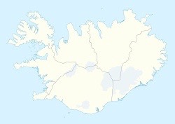
In Iceland, Keflavik is significant near Reykjavik and part of the ‘southern peninsula’ because that is where the airfield is at eight on the clock; at nine that is Snaefellsnes, “Iceland in miniature”; the crab claw at ten o’clock is the West Fjords; I had trouble identifying what was worthy of note here and have ignored the remainder.
Here’s a list of peninsulas in Asia, taken from here:
Al-Faw peninsula, Asia Minor (Anatolia), Arabian Peninsula, Atsumi Peninsula, Bataan Peninsula, Beirut, Bicol Peninsula, Bình Quới Peninsula, Bondoc Peninsula, Boso Peninsula, Cà Mau Peninsula, Cam Ranh Peninsula, Caramoan Peninsula, Cavite, Chi Ma Wan Peninsula, Chita Peninsula, Chung Hom Kok Peninsula, Colaba, Đầm Môn Peninsula, Datça Peninsula, East Peninsula, El Mina, Fan Lau, Gwadar, Haifa, Hòn Gốm Peninsula, Honshu, Indochina Peninsula
Indostanic Peninsula, Izu Peninsula, Jaffna Peninsula, Kameda Peninsula, Kapidagi Yarimadasi, Kathiawar, Kii Peninsula, Kolsky Peninsula, Korean Peninsula, Kowloon Peninsula, Leizhou Peninsula, Liaodong Peninsula, Lisan Peninsula, Malay Peninsula, Mangyshlak Peninsula, Matumae Peninsula
Miura Peninsula, Motobu Peninsula, Musandam peninsula, Nagasaki Peninsula, Nemuro Peninsula, Ngũ Xã Peninsula, Nishisonogi Peninsula, Noto Peninsula, Notsuke Peninsula, Oga Peninsula, Oshika Peninsula, Oshima Peninsula, Osumi Peninsula, Phương Mai Peninsula, Poluostrov Yamau, Pujada Peninsula, Qatar,
Sadamisaki , Sai Kung Peninsula, San Ildefonso Peninsula, Satsuma Peninsula, Semenanjung Blambangan, Semenanjung Minahassa, Shakotan Peninsula, Shandong Peninsula, Shikoku, Shimabara Peninsula, Shimokita Peninsula, Shiretoko Peninsula, Side Peninsula, Sinai Peninsula, Sơn Trà Peninsula, South Peninsula, South-east Peninsula, Stanley Peninsula,
Tinaca Point, Trà Cổ Peninsula, Tsugaru Peninsula, Wan Tsai Peninsula, Wan Tsai Peninsula, Yokatsu Peninsula, Zamboanga Peninsula.
looking on wikipedia I found a load more, which you could explore at http://en.wikipedia.org/wiki/Category:Peninsulas_by_country To make sense of this and to attempt to be interesting, I’ve gone looking for the bigger ones and the ones with a bit of history attached - to put that another way, to try to identify the ones we ought to have heard of. I notice that the wikipedia list manages to find peninsulas in land-locked countries, thanks to the several lakes.
The Lisan peninsula divides the Dead Sea, which is steadily disappearing.
The Sinai peninsula is that part of Egypt in Asia between the Gulfs of Suez & Aqaba at the northern end of the Red Sea.
The Malay peninsula includes the Kra Isthmus³, the narrowest part of the Malay.
The Kathiawar peninsula in (Gujarat) India is much the same shape as the Crimea up near Pakistan. it is bracketed by the Gulfs of Kuchchh on the left and of Khambhat on the right.
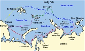

Russia has many. I rank the Kola and the Kamchatka as worth remembering; the Kola cuddles up to Finland between the Barents and White seas; the Kamchatka is on the other extreme coast on the Bering Sea, with Petropavlovsk on the end (not Vladivostok, which is almost in China). I’d add the Chuchki since that name is also one of the Arctic seas; the Yamal is that north-pointing tongue into the Kara Sea with the Gulf of Ob (big river). The Tamyr is between the Kara and Laptev seas. The Kanin is across the Barents Sea from the Kola peninsula – the two form the mouth of the White Sea. I choose to make Cape Patience the last of the Russians, being the 65km dangle on the centre right (east) of Sakhalin
IndoChina, the peninsula, is made up of Vietnam, Laos, Cambodia, Myanmar and Thailand. It has the Bay of Bengal in the Indian Ocean on the west and the South China Sea within the Pacific on the east. Politically, French IndoChina disappeared at the end of WW2, separating into what we now call Vietnam, Laos and Cambodia.
The Somali peninsula, also called the Horn of Africa, is on the extreme east of the continent, jutting into the Arabian Sea. the only other African peninsula of note is that of the Cape. You may disagree, in which case, please write by email.
In South America, the Valdes is that weird mushroom-shaped extrusion south of the mouth of the Rio Negro on the Atlantic coast of Argentina, is around 3600km² and is a nature reserve. The Mitre is a similar size and is the eastern end of Tierra del Fuego, the eastern end of the Cape (at a continental level – the Cape itself is the southernmost tip of the continental landmass). There are other large peninsulas in the area, such as Brunswick, Hardy, Taitao, belonging to Chile. I have ignored all others, while having looked to inspect if they are worthy of your attention. The Guajira is on the west of the gulf of Venezuela, shared between Colombia and Venezuela. Venezuela also has the Paraguana, on the other side of ‘its’ gulf just south of Aruba with a natural isthmus called Medanos. Paraguana has oil refineries and growing tourism. Paracas in Peru looks like a toadstool; it is a desert with an adjacent marine reserve. You might read up about the candelabra.
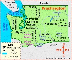
North America. I’m going to assume you already know Yucatan, Baja California, Florida, Newfoundland. North America also has that odd shape on the east coast, the Delmarva peninsula. Thanks to a canal, the Chesapeake and Delaware, it is now technically an island. Delmarva is a portmanteau of Delaware, Maryland and Virginia, the three states included. Of interest is the southern side of the Salish sea, in the Seattle-Vancouver region, which is now called the Olympic peninsula; Puget Sound to the east. I found some confusion in naming here: the Kitsap peninsula is the odd bit to the right of the Hood canal, immediately opposite—west—of Seattle; the larger part is then the Olympic, with the eponymous mountain range. You’ll have to wait for the Gaspé, but it is Canadian
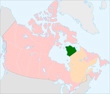
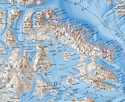
Looking at a large map, MIchigan has two significant peninsulas due to the Great Lakes, but they are boringly called Upper and Lower. Canada has many peninsulas, but I didn’t discover any worthy of further comment in BC. In Quebec, the Gaspésie or Gaspé is a bit bigger than Belgium, on the southern flank of the St Lawrence; New Brunswick is south, too. The mass of Quebec that forms the top right corner of Hudson Bay is the Ungava peninsula, part of the far larger Labrador peninsula, with Newfoundland on the extreme right. On the small map I included, the Ungava is in green, Labrador mostly orange and Newfoundland (an island) is pink. The Nova Scotia (province and) peninsula is in pink and immediately south of Newfoundland. I found a good map showing the region around Baffin Island.
In China, we ought to recognise Macau and HongKong, each of which have several. For the remainder - and ignoring the political issues of who owns what, covered elsewhere - we ought to know about Dapeng Peninsula, Leizhou Peninsula, Liaodong Peninsula, Macau Peninsula, Shandong Peninsula, Tashi Dor, Yangpu Peninsula, Yuantouzhu.
The Dapeng is east of Shenzhen in Guangdong, immediately east of HongKong.
The Leizhou is also in Guanghdong, being the large mass pointing at Hainan island.
The Liaodong points SW next to North Korea, forming the southern arm of Bohai Bay (or sea). You might call it the northern end of the Yellow Sea. In much the same place is the Shandong, pointing at Korea from the west; I lived in Shandong and maybe it should be called the Jiaodong.
Macao is not far from HongKong (really), since they are on opposite sides of the Pearl delta, the Zhu Jiang estuary, at Guangzhou.
Tashi Dor is a minute thing in Namtso Lake in Tibet. Maybe I should exclude it. Similarly Yangpu, on Hainan and YuantouZhu on Lake Tai near Wuxi in Jiangsu.
For Hong Kong, I failed to find a good map, but you might start here within Wikipedia.
Australia: Cape York is the pointy bit of North Queensland. I note here that Wikipedia omits the Bellarine & Mornington and (the east and west closures to the bay of Port Philip at Melbourne), Eyre, Yorke and Fleurieu (Adelaide; west to east; the first two bracket the Spencer Gulf, Yorke is the middle one shaped like Italy to the west of the city, Fleurieu south of the city). To the west of Darwin (the west side of the gulf of Carpentaria) is a huge headland most of which is called Arnhem land; the Gove peninsula is the NE tip. The Cobourg peninsula, 2100km², is a heavily indented piece of land at the NW of Arnhem land.
Greenland has many, but nothing of note but for Peary Land, in the far north, between the Lincoln and Wandel seas. Peary named it in 1891, but there is evidence of humanity as early as 2400BC. Wow; perhaps the island was further south at the time.
I’m sure there must be better ways of approaching this topic. Do make suggestions.
DJS 20150306
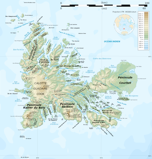
Kerguelen, mostly the big island Grand Terre, gives us the no-reason-to-know names of Courbet, Gallieni, Ralier du Baty, Loranchet, Jean d’Arc - and others. A good place to keep submarines. I wondered if it might be where the Thunderbirds lived, but it is too far from anywhere. I expect there is a fairly secret submarine base there. A great place for a nuclear plant.
1 I couldn’t. What is confusing is the apparent bay is confused by the huge delta of which Adana is the centre. Iskenderun is on the west of the bay. Is it the Seyhan river? the Sarus? Same river, two names. The Sarus used to join the Pyramus (also called the Ceyhan, which probably explains the name changes) and these combined rivers flowed into the med west of Karatash. See. Found it; Armenian Bay. Weird; Armenia is now a long way NE of there. At its largest, 95-66BC, Armenia ran from the Cilician sea to the Caspian and not quite to the Black, including all of what is now Syria. Back then this was (all) fertile land.
2 We learnt it is the Cilician Sea in essay 154.
3 Winston Spencer Churchill got me doing this. He refers to the Kra peninsula but meant the isthmus within the Malay peninsula.
4 Sandspits. Similar: The Priwall peninsula on the Trave river on the German Baltic. Cadiz, pointing at Rota, Spain (a NCIS favourite site) BUT the spit may not be a sandspit.
Not similar: the Kerch peninsula, in dispute between Russia and Ukraine includes the Tuzla spit. Not the same as the Troia and Hel. The Curonian spit and Lagoon is different, too, but similar with the Vistula spit and lagoon. Close to these two is Sandspit, Karachi, though the lagoon is open to the sea. Like these are Mudeford Spit and Hengistbury Head, Christchurch UK. La Manga is like this, Murcia, Spain. Lefevre in Adelaide is almost similar.
Sticking into the water are spits such as: Long Point, Ontario; Zlatni Rat, Croatia; Farewell Spit, north end of South Is, NZ; Dungeness Spit, Washington state; Sandy Hook, New Jersey; Homer Spit (Kenai peninsula) Alaska; Ediz Hook, Washington State. Anadyr in Russia is forming similar arms on the estuary. Sandy Hook NJ and Long Beach NY bracket Staten Island.
There are special cases in the Persian Gulf, where man is making some wonderful shapes (before the oil runs out). Images can be found by googling persian gulf man-made islands. Have a look at the coast of Bahrain and then Dubai, using Google Earth [turn 3-d buildings on, too].They’ll be ‘royally’ screwed if the sea rises!
Jutland the mainland of Denmark between the caspian and the North seas.
Anatolia the larger part of Turkey, between the Mediterranean and the Black seas.
Yucatan the rectangle of Central America that sticks up into the Gulf of Mexico
Shandong the dog’s head forming the southern end of Bahia bay, pointing at Seoul, Korea. Includes Qingdao.
Cape York the north-pointing narrow wedge of Queensland, NE Australia
Kamchatcka that bit of Russia closest to Japan, between the Bering and the sea of Okhotsk
the Wirral the small rectangle of England nudging the NE corner of Wales, between the rivers Mersey and Dee
the Gower a small part of Wales pointing west, on the south coast near Llanelli
the Crimea the rhomboid of land that sticks into the Black Sea. Includes Sebastopol.
the Kola the horsehead of land between the White Sea and the Arctic, extreme NE Russia. Sometime confused with the Kara, a large crater in the Yugorsky peninsula, on the shores of the Kara Sea, which has the Taymyr peninsula on the west and the Yamal on the east.
Liaodong the bit of China west of Korea forming the west side of Bahia Bay. Includes Dalian
Westfjord the big crab’s claw of Iceland in the NW
the Delmarva that combination of Delaware Maryland and Virginia which protects the Chesapeake
the Rhins the hammer-head of Dumfries and Galloway, SW Scotland including the southern limit of Scotland
Salentino the heel of italy
Ungava that part of northern Quebec on the east of Hudson bay. Some maps include the Torngat ridge further east too. I found (wrong) maps calling this Labrador, too. The larger peninsula may be called Markland rather than the Labrador peninsula, also referred to as the Canadian Shield
Giens the island and isthmus combination at Hyeres, Toulon airport nearby. Porquerolles island is nearby.
Valdes the hammer-head in the middle of the Argentine coast.
Gallipoli the north-western shore of the Dardanelles, between the Black and Aegean seas.
Gaspé that part of Quebec on the south bank of the St Lawrence, NE of Montreal and pointing NE
Istria that triangle of Croatia that pushes south into the Adriatic
