
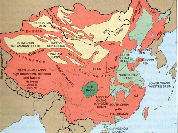
Much of this was found on the net in an article dated as ’99 by Robert W. McColl, who is the Geography professor at the University of Kansas. I have edited it to reduce the American nature and to make it less verbose. That doesn’t stop a comparison of China and the US being a really good topic for discussion. Pictures slow down the loading process and I have excluded them, so you will need a map (better, an atlas) to hand if you attempt reading the whole. Much of it reads like a textbook, which is only partly my fault and more of the nature of the work I lifted it all from.
China not only has the world’s largest population (over 1.3 billion), but it also is an extremely large country (more than 9.5 million square kilometres) with immense physical and cultural diversity. China should be viewed as an assemblage much like Europe. How does one integrate three thousand years of history, language, local cultural practices, diets, architecture, et alia with basic physical geographies and economics that range from subsistence farming and herding to sophisticated electronics and computer industries, cities like Shanghai or Shenzhen?
China can be divided into regions, which largely remain distinct. Each of the geographic regions discussed below at one time contained a distinct and separate culture, which over time have become melded into what is modern China.
Regionally Distinctive Characteristics
It is important to understand that not all Chinese are alike or eat the same foods or talk the same way or even think the same. For example, some speak of the "Yellow River Valley" as a kind of uniform entity, despite its origins in the high Qinghai Plateau, passage through the arid loess plateau and gorges of Shaanxi, and finally across the open plains of North China.
The North China Plain
This typifies, even stereotypes, our standard image or myth of China and the Chinese. Here are found the peasant farmers living in closely packed villages built of mud or adobe, although today many of these traditional dwellings are being faced with fired brick. It is an area subject to the extreme heat and droughts of summer and the floods of spring. Life on the North China Plain is commonly perceived as one of self-sufficiency and subsistence. Historically the inhabitants of the plain have had to endure endless depredations by armies and bandits who swept across the area in search of food or other loot, yet it is an environment of little surplus and no natural mineral or other wealth. It was a perfect environment for missionaries, and later communists, to bring a message of hope to the often utterly destitute. Still, it also was referred to as the "good earth." I can’t think why.
The Loess Plateau
While not as familiar to Westerners as North or South China, the Loess Plateau is an area of great historic importance to the Chinese. It was the site of the headquarters of Mao Zedong and the Chinese Communist Party just prior to their conquest of China in 1948. In ancient times, this region was the meeting zone between the nomadic herders of the Mongolian and Central Asian steppe and the more settled farming communities of what would become China. It was on the margins of the loess areas that the great trading cities and capitals of empire first formed—Xi’an or Chang’an being the best known.
Because winters are harsh, water scarce, and trees even scarcer, traditional houses were caves cut into the friable loess. In 1999, some forty million people still lived in underground (cave) housing. As with North China, it was an area in which poverty and banditry traditionally were endemic. Only the cities could become wealthy and then only via trade with areas outside the immediate region.
The Sichuan Basin
Among the Chinese it often is said that "Sichuan is the first province to declare independence and the last to be reunited after there is peace." This well illustrates the ability of Sichuan to be wholly self-sufficient from the rest of China. In dramatic contrast to North China or the Loess region, Sichuan is a province and region that can produce virtually any product grown anyplace in China. It has sufficient surplus so that it has no need for imports of foods or even raw materials. It truly is a land of independence—and its politicians (including Deng Xiaoping) and warlords have often behaved that way. Its climate generally is mild, and its location provides access to every major economic and physical environment in China—Tibet, the Loess Plateau, the Yangtze Valley, and the Southeast uplands. All it lacks is easy and secure access to the sea. There are two principal cities, Chengdu and Chongqing.
The Southeast Coast and Shanghai
In the 1990s this was the area of the most active economic growth and development in China. It also was the region to first experience Western impact via the Opium Wars and "Treaty Ports." It is an area with historically the greatest number of Christian missionaries, Chinese Christians, and Christian churches. Like so many distinct physical environments in China, it is dominated by ethnic peoples not fully identifiable as "Han" who speak distinct languages and who often have closer ties to Chinese overseas than to those in Beijing.
The Yangtse Valley
Separated from other regions by mountains and extensive wetlands, the Yangzi (Yangtze or Changjiang "long river"), is the focus of life and economics here. Fishing and commerce by boat dominate life and culture. Cities such as Wuhan and Nanjing are dominated by economies tied to water-borne transportation and commerce—not agriculture or even food processing. The development of the Three Gorges project (can you locate it?) reflects many of the changes in China: power demand, the economy and openness to new ideas being just a start.
Major manufacturing centres exist along the river because of its cheap transport. There are large numbers of "boat people" who live their entire lives on small and medium-sized boats. They and make a living moving goods and people via the numerous lakes, canals and rivers of the entire Yangzi valley, especially in the areas around Shanghai. Contiguous to the river and dependent upon it for their cultures and economic well-being are the lake districts and provinces such as Hubei, Hunan, Jiangxi, Anhui, Jiangsu and Zhejiang.
Xinjiang
Contrasted with eastern China, Xinjiang is a landscape of deserts, mountains, and oases. Located between the cultural empires of China in the east and Persia and Central Asia in the west, Xinjiang was an important historic link. One result of this intermediate position is that Xinjiang’s people are predominantly Moslem and Turkic in ethnicity and language. Because of their proximity to Persia, their agricultural history is more closely linked to the mercantile cities and trade of the ancient Silk Road than the irrigation practices of eastern China.
In the northern part of Xinjiang, the Junggar Basin, people have a long association with various Mongol peoples, and because this area has more moisture and grass than the Tarim Basin in the south, they are more pastoral than nomadic. The Tarim Basin was more closely related to Persia and the Islamic influences of the Middle East. It also was a traditional link (via the Silk Road) between Persia and the Middle East and eastern China. The Tarim Basin is characterised by city-dominated oases and mixed farming and animals (mostly sheep). In the Tian Shan (mountains that divide the two basins), the people are nomadic. Typical housing would include the yurt (there are examples in Cornwall in central Bodmin moor)
Northeast (Manchuria)
As with Xinjiang and Tibet/Qinghai, Northeast China is one of the least typical environments compared to most of what is viewed as China in the popular mind. Winters are damp and cold. The best agricultural crops are commercial crops such as soybeans and sugar beets. Ice festivals mark winter holidays. Where the forests remain abundant, houses are built of wood and resemble housing in Russia’s Siberia.
Regionally, diets are much richer in animal proteins and soybeans than in the rice and vegetables of central or southern China. Because of its rich coal and iron resources, the region was industrially developed by the Russians and Japanese, so it has more railroads and heavy industrial manufacturing than any other region in China. Perhaps a fitting analogy would be Germany’s Ruhr Valley or the Pittsburgh area of the US.
Tibet and Qinghai
Best known as the home of the Dalai Lama and the Tibetan (Yellow Hat) form of Buddhism, the Tibetan and Qinghai plateaus are extremely high in elevation (an average of 4,000 meters (14,000 feet). They have a very sparse population for an area of about 2 million square kilometres and a combined population of only 6.5 million. Most of these people are concentrated in only two or three cities. Other than in the more verdant areas of the south face of the Himalayas and the subtropical mountains along the Sichuan border, the region is dominated by vast expanses of flat terrain dotted with lakes – most of which are saline. It is a harsh environment, not well suited to human use, and certainly not to crop agriculture. Typical shelters for the nomadic herders are felt tents during the summer and low mud and dung huts or rock shelters for the winter. The cities are typically dominated by monasteries with thick walls that slant inwards and small windows.
Diets are dominated by yak butter (for fat and vitamins) and toasted barley. There are few green vegetables, and meat is a staple. A major limit on food availability is the high altitude that allows water to boil at very low (non-cooking) temperatures. This makes cooking meat extremely difficult without some kind of pressure cooker.
Southwest Uplands
Southwest China is a landscape of dissected plateaus, dense forests, and great ethnic diversity. This is one of China’s most inaccessible regions and thus one of its more economically backward as well. The hilly terrain makes bicycle traffic almost impossible, and most people travel by foot, water or horse.
Hillsides were largely denuded during the Cultural Revolution (1966–76) but have been replanted – mostly with eucalyptus trees imported from Australia. This planting proved quite a mistake and is worthy of an essay in itself. There are tin mines in the south, near the border with Vietnam, originally developed commercially by the French. Plans to develop closer economic ties with Myanmar, Laos, and Thailand make a lot of sense.
The linguistic and ethnic ties between these peoples, however, imply a future integration in the development of trade with Southeast Asia as well as growing economic independence of Beijing and North China.
Connections
Transportation remains the most crucial factor in tying the country and its regions together. The development of a common language is more recent than you would think and cultural values are being shared in a way that produces commonality. Unlike the Roman Empire, the Chinese Empire has demonstrated an uninterrupted cultural and political history. Discuss!
Because the origins of its empire lay in the interior of China—especially Xi’an—roads have been perceived as more important than the waterways. Roads, of which the Silk Road is the best known to non-Chinese, followed the oases and core areas of historic China, much as you would expect. An example to research is the Shu Dao that links the Wei valley of Xi’an with the Sichuan Basin (Chengdu). Similarly the Qinling mountains, between Xi’an and the Three Gorges, provide an engineering challenge equivalent to those found in the Pyrennees or the Dolomites.
The Grand Canal was built a very long time ago, but recorded as of national importance by Song times (960–1279). It originally linked the lower Yangtse Valley and Hangzhou, passing through Kaifeng (the Song capital) on the Huang Ho and it was extended some time later to Beijing. There is a major crustal fault in the wetlands between the Yangzi and the Huang Ho (the Yellow River), of which advantage has been taken.
Where the rivers are large and slow, the traffic on them is significant in number and volume. This applies particularly to central China and the Yangtse River region. Where the river was usable, such as the three gorges area where the Daning meets the Huang Ho, trestle roads were the transport link. Much more on rivers is written further down.
In the modern era, the railways offer a reliable way of moving heavy goods, and although much effort is going into improving the road network, the distances involved remain significant. China is much the same size as the US, with three (wrong, more than four)) times the population. However, one must not underestimate the importance of television and telephones (as well as the airlines) in keeping the Chinese viewing themselves as one people and culture. Their value in political control was demonstrated in 1989 when televised "wanted" posters were broadcast instantaneously across all China, and in June of 1997 when the return of Hong Kong became a national rallying point—again, across all of China and at the same time. As the internet becomes more available – you might research the development of the data net in China, initially by looking perhaps at China Telecom – so access to information is made easy. This has an effect on the political landscape.
As important as physical means of transportation and communication in creating a common culture has been political organisation. No empire or state can exist without both cooperation and means of enforcing order among such disparate geographic areas and peoples. This was the primary achievement of the first "emperor of China," Qin Shihuangdi, in 221 B.C.E. This first emperor defined the empire’s borders with Central Asia and established common laws for everyone in every geographic sector of the country.
In modern times (go on, when?) the reunification of the geographic regions, often historically independent kingdoms or "states", under a common Communist ideology was a major achievement of the Chinese Communists and the People’s Liberation Army. Political organisation in China has been successful in part because it recognises the very distinctiveness of various geographic areas. Today, large cities such as Shanghai, Beijing, Tianjin, Chongqing, and Hong Kong have special political status. Likewise, key economic cities (list? I guess Xi’an, Nanjing, Chengdu belong in it) have been created and given special political status to provide controlled access to modern economics and world trade. Finally, geographic areas dominated by non-Han Chinese cultures and peoples, such as Xinjiang, Ningxia, Tibet, Inner Mongolia, and Guangxi have been given political status (at least on paper) of being "Autonomous Regions." Even at the local level, it is common to find special status given to cities or even geographic areas that require some kind of special political status to maintain political peace and order—a kind of geopolitical "gerrymandering." The Russian states have issues with ethnic Russians not dissimilar to the Han in China – research & discuss.
Major Rivers
China's two major rivers, the Huang He (Yellow River, Ho and not He, above) and the Chang Jiang (Yangzi or Yangtze River), as well as the Pearl River (Zhu Jiang) delta system marked by the Xi Jiang (West River) in southeastern China, have provided the framework for agricultural development and population growth throughout China's history. Another river, the Heilong Jiang (known also as the Amur, its Russian name) marks the border between China and Russia; at times in the past, this area was one of confrontation between the neighbours. The drainage basins of China's rivers differ in terms of extent and topography, offering varying opportunities for agricultural development. Because some of China's largest rivers have their source regions on the high Qinghai-Tibetan Plateau and drop great distances over their middle and lower courses, China is rich in hydroelectric resources.
Each of these rivers has special characteristics and associated problems at different locations along their courses. (Note that "he" and "jiang" are both translated into English as "river". In English, there are of course many words that differentiate flowing water according to size and character--stream, brook, creek, river, just for example. In the Chinese language, similar differences are expressed but the common words usually translated into English as "river" can be further clarified somewhat. Jiang is the most common descriptor for "river" in Chinese, signifying a stream that is often geologically young which cuts through a narrow valley. He, on the other hand, is generally used for a river that is broad and geologically old. In this regard, much of the lower course of the Huang He is reminiscent of the sluggish Mississippi River while the middle and upper sections of the Chang Jiang resemble the unruly Colorado River. It is thus redundant to say Huang He River or Chang Jiang River)
China's second longest river, the Huang He rises in Qinghai province and flows some 5464 km to the Yellow Sea. Crystal clear lakes and sluggish meandering are characteristic in its upper reaches. Along the Great Bend of the Huang He in its middle course, the unruly river carves its way through the loessial plateau with substantial erosion taking place. As the river erodes the loess, it becomes a "river of mud" (Loessial soil is called huang tu or "yellow earth" in Chinese and it is the colour of this suspended loess in the river that has given the Huang He its name) Carrying 40% sediment by weight in summer - in other rivers 3% would be considered a heavy sediment load -the river deposits vast amounts of alluvium as it courses across the North China Plain. Over the centuries, deposition has raised the bed of the Huang He so that it is in some ways "suspended" precariously above the lower surrounding agricultural areas, contained by levées and embankments built to control what historically was "China's Sorrow" - the bringer of flood and famine.
The lower course of the Huang He has changed 26 times in China's history, most notably nine times including major floods in 1194 AD and again in 1853, that brought untold disaster to the villages and towns of the North China Plain. (See Map of Course Changes of the Huang He.) What was once a scourge that plagued the Chinese people throughout much of their history continues to be one of China's great natural challenges - preventing both flooding and drought in a region with more than 100 million people. Silting at the mouth of the Huang He extended the length of the river by about 35 km (20 miles) between 1975 and 1991. The North China Plain is indeed a "gift" of the Huang He.
Throughout the loessial uplands, some 40 million Chinese still live in cave-like or subterranean dwellings that are an especially appropriate response to the peculiar nature of loess and the absence of alternative building materials such as timber.
As China's "main street," this artery that is the Chang Jiang travels over 6300 km through several of China's most economically developed regions. Excellent river ports - Shanghai, Zhenjiang, Nanjing, Wuhan, Yichang, and Chongqing - are located near or along the Chang Jiang, making it one of the world's busiest inland waterways. As much of 40% of the country's total grain production, 70% of the rice output, and more than 40% of China's population are associated with its vast basin that includes more than 3,000 tributaries. The flow of the Chang Jiang is some 20 times greater than that of the Huang He. With its numerous tributaries, the Chang Jiang drains nearly 20% of China's total area. Its upper reaches tap the uplands of the Tibetan Plateau before sweeping across the enormous and agriculturally productive Sichuan Basin that supports nearly 10% of China's total population. It is in the middle course of the Chang Jiang that the controversial Three Gorges Dam project is being constructed.
As a huge public works project -- the largest dam in the world, rivalling the building not only of China's great historical projects such as the Grand Canal and Great Wall as well as modern projects elsewhere in the world -- the Three Gorges Dam project is wrapped in environmental, engineering, and political controversy. Increasing clean energy, controlling floods, and stimulating economic development are but a few of objectives of the dam. Below the Three Gorges Dam are the great flood plains of the Chang Jiang as well as the major tributaries on its north and south banks. At the mouth of the river is the great and productive Yangtse delta and metropolitan Shanghai. With the completion of this project, the frequent disastrous floods are expected to be eliminated.
The second worst flood of the past 130 years struck the Chang Jiang valley in Summer 1998 and affected 240 million people, killing some 3656, and leaving 14 million homeless. The flood is estimated to have left 14 million people homeless, destroying 5 million houses, damaging 12 million houses, flooding 25 million hectares of farmland, and causing over US$20 billion in estimated damages. On the adjacent (now suppressed) infrared image, the extensive flooded area is shown in blue, other water areas in black, vegetation in red, and clouds in white.
Situated in Guangdong province just to the north of Hong Kong and Macao, the delta of the Zhu Jiang is the most significant farming area in south-eastern China. Some regard it as one of the most productive and sustainable ecosystems in the world because of its integrated dike-rice paddy-fish pond agricultural system. Between 1988 and 1995, land reclamation along the banks of the river and along the coast added farmland and space for fishponds as well as created space for rapidly expanding settlements.
Early Civilizations
Looking at the (sorry, a) map of historical borders and the map showing the major rivers highlights the important fact that the earliest hearths of Chinese civilisation developed along its river valleys. One of the cradles of Chinese civilisation, the Neolithic site called Banpo, was located along a tributary of the Huang He not too far from the present-day city of Xi'an in Shaanxi province. Hemudu, on the southern shores of Hangzhou Bay that lies to the south of the Yangzi River delta, is another of China's important Neolithic sites. The Shang dynasty (c. 1600-1027 BC) was also situated around the Huang He and eventually spread southward to the Chang Jiang and Xi Jiang.
Mountains and Deserts
The west of China is comprised of mountains and deserts as well as plateaus (plateaux?) that do not provide much arable land for agriculture. Throughout most of history, the civilisation that grew up to the east in what is today China was not surrounded by other nearby major civilisations. To this extent the Chinese were "isolated" from competing civilisations although there was a broad and fluid frontier zone on the western margins. This geographical fact is important to remember when discussing the Western encroachment on China from the sea during the late imperial period. Go on, discuss it.
Although the mountains and deserts of the west limited contact between early imperial dynasties and other centres of civilisation in the Inner Asia, Middle East, South Asia, and Europe, there were some important and notable exchanges of culture. The legendary Silk Road facilitated the exchange of goods and ideas between China and each of these areas.
Historical Borders
Like many other countries, the historical borders of China have varied over time. Under the Han dynasty (202 BC-202 AD), China's great historical empire, these early boundaries were significantly expanded, as the series of historical maps of China shows (go find it). The extent of China's territory was greatest under the last dynasty, called the Qing (Ch'ing) or Manchu dynasty between 1644-1912. China's territory was more extensive under the Qing empire than it is today.
Bordering Nations
China is at the core of a cultural sphere or region known as East Asia. Looking at the map of bordering nations, it is possible to identify China's neighbours, some of which received substantial cultural influence from China. China, Korea, Japan, and Vietnam historically form the East Asian or Sino-cultural sphere.
The large number of countries (20?) with which China shares borders makes Chinese foreign policy especially complex (unlike the US., for example which shares borders only with Canada and Mexico).
Great Wall, Grand Canal, Terracing and Irrigation
The Chinese attempted to correct perceived "deficiencies" in their physical geography by building massive civil engineering projects that would help bring about unity and provide defence as well as by countless smaller scale efforts at modifying their physical landscapes.
* Great Wall. What is known today as the Great Wall (you need a map) was reputedly first completed during the Qin (Ch'in) dynasty (221-206 BC) when segments of the wall existing from earlier periods were connected. Early walled ramparts were constructed of rammed or tamped earth. The brick-faced walls seen today were built much later during the Ming dynasty (1368-1644). Although not a single continuous wall, the Great Wall and its associated military encampments and guard posts figured in attempts by many dynasties to manage the nomadic peoples, sometime referred to as "barbarians," who lived north of it on the grasslands or steppes. For the most part, the Great Wall should be viewed as a zone of transition - rather than a fixed border - between farming areas with sedentary villages and pasture lands with nomadic lifestyles.
* Grand Canal. Since China's major rivers—the Huang He and Chang Jiang—flow from west to east and there is no natural communication north to south except by way of a coastal route, the Chinese dug the Grand Canal as a safe, inland water route between the two major rivers, in the process connecting a number of minor regional rivers. Constructed around 605 AD to serve commercial as well as military considerations, the canal was extended several times, most notably to Hangzhou in 610 and eventually in 1279 to Dadu, the great Mongol (Yuan dynasty) capital. During the Ming and Qing dynasties which followed the Mongol dynasty, the Grand Canal ensured that Beijing, the great successor imperial capital to Dadu, had sufficient grain from the southern rice bowl areas. The Grand Canal is the longest artificial waterway in the world and has a long history of barge traffic along its course. Although many parts of it have fallen into disrepair over the years, it is still possible to traverse the canal from Hangzhou, Zhejiang Province northward 1801 km to Beijing.
Terracing and Irrigation. At least as significant as major engineering works like the Grand Canal and the Great Wall are the countless alterations of China's physical landscapes by centuries of human effort. These human modifications traditionally focused on terracing hill slopes and controlling water via irrigation as well as reclaiming marginal land. In managing natural resources and expanding opportunities for the production of food, the Chinese have reclaimed, even created, land that in many areas of the world would have been considered impossible to farm.
Throughout the rugged areas of northern and southern China, farmers over the centuries have sculpted the hilly land into step-like (steppe-like?) landscapes of terraces. Sometimes terraces are relatively natural features that need only be modified in order to produce level areas for planting, while in others extraordinary efforts must be carried out to move earth and rock, stabilise retaining walls, and create sluices for controlling the flow of water. Drainage control and water storage are as important as the level land itself.
Managing water resources is necessary to reduce erosion and make water available for terraced rice production. Seen from the air, much of China glistens with countless water surfaces that have been created by human labour. Really. The building of terraces on sloped land not only creates level land but also provides a means of "managing" rainwater by controlling its runoff. As rain falls on hill slopes, it tends to erode them relatively easily, but when the velocity of the water is slowed because it is impounded in irrigated fields erosion is reduced. The impounded water then can be controlled as it flows gently from a higher level to a lower level. As water falls from level terrace to terrace, the speed with which the water flows beyond the fields where it is needed is minimised. Usually fine silt is suspended in the flowing water that then is deposited in the lower fields rather than being carried farther away. Besides the obvious irrigation systems that are fundamental to terraced rice production, other systems control water flow and drainage on adjacent paddy fields that are nearly at the same level. Small-scale and large-scale water conservancy projects continue to be important means of increasing crop production as well as reducing flood and drought.
Population and Agriculture
It is a well-known fact that China is the most populous nation in the world. China's total (1999, so you should revise these figures) population of 1,252,800,000 nearly exceeds the combined populations of Europe (579,700,000) and South America (311,500,000) and the United States (272,573,000) and Japan (125,200,000). By comparison, the population of the United States is equivalent to only 22% of China's population.
Such a huge population imposes substantial stress on the country's natural resources, including especially arable land. Although China ranks fourth in the world in terms of total arable land, the pressure of population on this precious available agricultural land is acute and makes China's struggle to increase its agricultural output to feed its population all the more difficult. Looking at a map (please do) of China's agricultural regions and crops, you see that China's arable land is primarily in the east, the same area where a majority of China's population is concentrated. In addition to extensive areas of western China which are relatively uninhabited, substantial portions of southern China are unfavourable for agriculture because of mountainous topography. There are significant variations from province-to-province in terms of cultivated land, multiple-cropping, and overall production of various crops.
China feeds somewhat less than one-quarter (25%) of the world's population on approximately 7% of the world's arable land.
You want a map that shows US and China superimposed: it can be seen that China has only a slightly larger land area, 3.69 million square miles compared to the 3.68 million square miles of the United States. However, while approximately 40% of the U.S. land can be cultivated, only 11% of China's land is arable. Much of the arable land in the United States, of course, is actually not used for farming but instead is used for pasture or has been developed for other uses.
Like China, the U.S. has a densely populated east coast. Unlike the U.S., however, China's farmland is not concentrated in a relatively underpopulated central section of the country. Of the roughly 273 million population in the U.S., less than 3% are engaged in farming while the U.S. has about 80% more farmland than does China and 10 times more farmland per capita.
Create a map comparing the population densities in the United States and China.
Despite the high population density reflected on a suitable map, China is not an urban society even though its total urban population (311 million) passes the total population of the United States. (The urban population of the U.S. at the turn of the century was 194,700,000, about 75% of the total; many Americans, of course, live in suburban communities.) Although some seventy-four per cent (74%) of China's population is still primarily engaged in agriculture and living in rural areas, these same farming areas have undergone substantial industrialisation and commercialisation since 1979.
Agriculture in China
The production of grain accounts for some 80-90% of all agricultural crops in China. Rice, wheat, corn, barley, and millet are the principal grain crops, each of which represents a particular adaptation to specific environmental conditions.
Wet rice or paddy rice agriculture is carried out particularly in fertile areas of southern and central China where a mild climate favours two and sometimes three crops per year. The growing of rice is frequently rotated with other crops such as winter wheat, sweet potatoes, corn, and vegetables of various types. Vegetable oil producing plants - specifically oil seed rape (known in the U.S. as canola), peanuts, and sesame - are widely grown throughout this region on appropriate soils.
In addition to relatively mild winter temperatures and a long growing season, heavy and predictable summer monsoon rains and overall sufficient annual rainfall are the basis for substantial productive agriculture. It is important to recognise that China's southern and central rice-growing regions are quite diverse.
Briefly explained, wet rice agriculture is an intensive farming system in which dense populations and the intensive use of the earth are complementary.
Rice seeds are sown broadcast in seedbeds where the densely packed seedlings are allowed to grow for approximately a month before being transplanted into fields. The preparation of fields by ploughing and harrowing is labour intensive activity as is the transplantation process. Water must be moved on and off the planted areas according to a schedule, during which on-going weeding is carried out to insure maximum yields. Harvesting and the preparation of the rice for storage are additional labour-intensive activities requiring more people. Although some mechanisation of the process of rice production has occurred over the centuries, the production of paddy rice continues to involve the intensive use of human labour even to the degree that there sometimes is insufficient labour available for a particular activity. The student reading up on (about) wet rice agriculture should describe the relationship between the rice cycle and Chinese family patterns. You might also read up on dry cultivation of rice and compare the land area used with that for wet-grown rice.
Note the area called "Sichuan rice." Sichuan is one of the most densely populated provinces in China today. Sichuan, including the Municipality of Chongqing which is now administratively separate from it, has a total population of 107,000,000. Sichuan has a greater population than any European nation except for Russia.
Geography and Regions
The cross-hatching nature of China's five mountain ranges (list?), the step-like staircase decrease in elevation from the lofty Tibetan plateau towards the sea, and the location of rivers make for a number of distinct geographical regions that fall into a checkerboard composition of basins, plateaus, and plains. Note the problems these pose for political and economic unity.
For the sake of elementary convenience, the landmass of China can be divided into two basic components, despite the fact that the Chinese themselves divide the country into North & South using the Huang He (although the Qinling mountains between the two major rivers make a more sensible divider):
* A vast Western region occupying nearly 2/3 of the country that is generally too high, too cold, and/or too dry to support a dense agricultural population. Much of this higher western area occupies the two upper steps of the topographic staircase: Qinghai-Tibetan plateau, sometimes known as the "roof of the world" with average elevations above 4000 meters and a broad arc-like step running northeast/southwest from the grasslands of the Inner Mongolian steppes through the deserts and basins of Xinjiang to the Yunnan-Guizhou plateaus of southwestern China.
* An Eastern region occupying 1/3 of the country -- that portion of China east of the Tibetan Plateau and generally south of the Great Wall -- forming the core of China Proper. It is framed on the west by mountain ranges about 1000 metres in elevation -- Greater Khingan, Taihang, Wushan, and Xuefeng -- and includes the densely settled North China Plain along the lower course of the Huang He and numerous plains in the middle and lower reaches of the Chang Jiang. This diverse region includes the eighteen traditional provinces of imperial China, and can be divided into Northern China and Southern China with the Qinling Range and Huai River forming the natural zone of demarcation between them. It is customary to include Northeast China, often still referred to as Manchuria, in this Eastern region.
Interregional Trade
A benefit of China's varied geography is that a shortage of resources in one part of China can be overcome by trade with another part. In this way China historically has been able to develop internally by promoting interregional trade, as opposed to going outside the country as many smaller European countries had to do. Instead of industrialising to overcome shortages, China traded within its own borders, thus promoting commercial development.
Similarly, a shortage in labour in one area could be filled by migration within the country or by shifting manufacturing to another area. Geographic factors that facilitated this internal trade were the Chang Jiang (Yangtse), the complex network of rivers in the south, and China's long coastline. China thus did not feel great pressure to develop labour-saving technologies or to engage in extensive expansionist or colonising activities beyond its borders, in contrast to the West and Japan. (This contrasts markedly with the political and economic history of Europe, where the existence of many small countries led to trade barriers and local shortages, prompting individual countries to make technological advances and wage costly wars that contributed to the rise of large financial empires and engage in expansionist imperialism.)
Disparity among Regions
A recurrent problem, however, is that some regions in China have developed more quickly than others because of their location. For example, the coastline of China with its ports and fertile soil has developed more rapidly than western China with its deserts and mountains. Western China is more isolated and thus lags behind the coastal regions, a condition that can be seen clearly in a view of the Earth at night where only lights and fires are visible.
Compare (again) the U.S. and China to highlight the importance of location and physical geography to economic development.
Political Divisions
The People's Republic of China has 34 major political divisions; 23 provinces, 4 municipalities, 5 autonomous regions and one special, the SAR of Hong Kong. Bear in mind that the PRC considers Taiwan to be one of its provinces, Taiwan remains politically separate as the Republic of China.
* 4 municipalities--Beijing, Shanghai, Tianjin, and Chongqing. Because of their size and other characteristics, these four cities have been given provincial-level status and report directly to the central government.
* 5 autonomous regions. The title "autonomous region" indicates that a substantial proportion of the population in the region is composed of minority nationality peoples whose language, culture, and particular social traits are distinct from the dominant Han culture; for the sake of political unity, the regions are given special consideration by Beijing in policy formulation. The regions are otherwise not "autonomous." (Eight percent of China's population is composed of minority nationality peoples. There are 55 distinct minority nationalities in China) A crucial factor is that these minority nationalities occupy 50-60% of Chinese territory--most notably Xinjiang (where China's nuclear installations are located), Mongolia, and Tibet. Identify them !
* 1 Special Administrative Region (SAR). Hong Kong gained this status on July 1, 1997 when it ceased being a British Crown Colony. Macao, once a colony of Portugal, reverted to Chinese sovereignty on December 20, 1999 and became the country's second SAR.
Questions for Discussion
Map-based:
1. Using the points of the compass, north, south, east, and west, where does China have land borders? Sea borders?
2. Is China's terrain varied in terms of lowland, mountains, river systems, desert land, and sea coast?
3. Where do you think the earliest inhabitants of China would be likely to settle? Why?
4. Can you tell if all Chinese people speak the same language?
5. Can you tell what are the most populated areas of China today?
Middle School:
1. In which continent is China?
2. With how many countries does China have a common border?
3. Using an outline map of China, can you draw in (a) China's rivers? (b) China's mountains and deserts? (c) China's most important cities? (d) a blue line indicating China's sea coast?
4. Water and rivers have always been very important in Chinese history. Can you tell why?
5. What part of China would be best for (a) traveling by camel? (b) mountain climbing? (c) finding high pasture lands?
6. What part of China would be best for (a) ploughing fields for crops? (b) growing rice?
7. Looking at your map, where do you think most people would be likely to live? In the west of the China? The east? Why?
8. What can you tell about a river that changes its course as the Huang He (Yellow River) has over the centuries? What sort of terrain would allow a river to change its course?
9. Has China's area changed over time? When was it smallest? When was it biggest? How do those compare with the situation now?
10. Why would the Chinese want to build the Great Wall? Why build it where it is instead of somewhere else? Why would the Chinese build canals? Why build them where they are? How do you think the Great Wall and the Grand Canal were built? By hand? By machine? How many people do you think it would take to build a mile of the Great Wall or of the Grand Canal? How fast could this mile be built? How would you get the people to work on such projects?
Rivers, Borders, and Civilisations
Major Rivers
1, What are China's two major rivers? Answer this before reading Q2-4.
2. Zhu Jiang (Pearl River)
a) What kind of land surrounds this river?
b) What is grown in this river's ecosystem?
3. Huang He (Yellow River)
a) Why is this river called a "yellow" river?
b) Why is this river called "China's Sorrow"?
c) What is loess? How is it useful for human habitation?
4. Chang Jiang (Yangzi River)
a) Why is this river called China's "main street"?
b) In what part of China are the upper reaches of this river?
c) Why is happening in the area called "The Three Gorges"?
Research questions:
1. If you wanted to travel in China with (in, by) a row boat, which river would you choose to go on and why?
2. Could you travel by boat from one river to another without going into the open sea or carrying the boat across land? Which parts of China could you see if you did this?
Early Civilisations
1. Where were the ‘cradles’ of Chinese civilisation? Why do you think people chose to settle in these places?
Mountains and Deserts
1. Why was China's early civilisation relatively isolated from other early civilisations?
2. What sort of terrain did the eventual route between early China and other civilisations follow?
Historical Borders
1. Have China's borders changed over time?
2. What geographical features can be found on China's borders?
3, Is it easy to travel across China's borders in terms of the terrain?
Bordering Nations
1. How might China be considered the core of East Asia?
2. What countries in East Asia have been particularly influenced by China?
Supplementing Geography
1. The Great Wall (Changcheng, literally, the Long Wall)
a) When were the first segments of the Great Wall begun?
b) What is the Great Wall built out of?
c) What was the purpose of the Great Wall?
2. The Grand Canal
a) What was the purpose of the Grand Canal?
b) When was the original canal built?
c) Can it still be used today?
3. Terracing and Irrigation
a) Why do people build terraces on hill slopes?
b) How is water managed on terraced hill slopes?
Population and Agriculture
1. Is China the most populous nation in the world?
2. Where is China's most arable land?
3. What areas of China are most populated?
4. Which country is bigger, China or the United States?
5. How do the most populated areas of China and of the United States differ?
6. What crops do the Chinese grow?
7. What is meant by "wet rice cycle”?
8. How much of the world’s rice is grown in China? How much is grown ‘dry’?
Geography and Regions
1. What is the difference between the western and eastern regions of China?
2. Why is interregional trade important in China?
3. Do the differences between the regions create problems for China?
Political Divisions
1. How many provinces are there in China?
2. What cities have provincial-level status in China?
3. How many autonomous regions are there in China?
4. What is the Special Administrative Region (SAR)?
Research project:
Plan a trip in China so that you can travel by boat, by train, by car, by foot, and by camel. Decide which parts of China would be best for each mode of transport. Imagine what you eat in the different regions you travel through. If you needed to talk with the local inhabitants, how many languages would you need to know? Would you need different clothes in different regions so as not to be too hot or too cold? If you stayed in the homes of the local inhabitants, how would these homes be constructed?
References
NASA photographs taken from the Space Shuttles and the Russian Space Station can be viewed at the following websites: http://images.jsc.nasa.gov or http://shuttle.nasa.gov or http://ersaf.jsc.nasa.gov.
Vegetation Maps from AVHRR-NDVI
Maps with political boundaries, along with cloud-free mosaics of imagery from space can also be found on the "Map Machine Atlas" available on the National Geographic Society’s website: www.nationalgeographic.com. I prefer Google Earth for simplicity, but colour satellite images related to China, along with discussions of their interpretations, can be found in various issues of the journal, GEOCARTO.
Articles and books that provide a sense of place and human/environment relationships would include:
Buxton, Leonard H. China: The Land and the People. New York: Gallery Books, W. H. Smith, Pub., 1988. A great collection of photographs and short descriptions of people and places.
Drege, Jean-Pierre and Emile Buhrer. The Silk Road Saga. New York: Facts on File, 1989.
Edmonds, Richard Louis. Patterns of China’s Lost Harmony. New York: Routledge, 1994.
Chiu, Huan-hsing and Zhongmin Lu. Folk Customs of China. Beijing: Foreign Languages Press, 1992.
Han-yèuan Yao. The Grand Canal: An Odyssey. Beijing: Foreign Languages Press, 1987.
Hsieh Chiao-min and Jean Kan Hsieh. China: A Provincial Atlas. New York: Macmillan Publishing, U.S.A, 1995.
Knapp, Ronald G. The Chinese House. Hong Kong: Oxford University Press, 1990.
——. China’s Vernacular Architecture: House Form and Culture. Honolulu: University of Hawaii Press, 1989.
——, ed. Chinese Landscapes. The Village as Place. Honolulu: University of Hawaii Press, 1992.
McColl, Robert W. "House and Field in the Karakorams." FOCUS, vol. 37, no. 4 (American Geographical Society, 1987).
——. "By Their Dwellings Shall We Know Them—An Analysis of Housing Form and Function Among Inner Asians." FOCUS, vol. 39, no. 4 (1989).
——. "China’s Modern Silk Road." FOCUS, vol. 44, no. 2 (1991).
——. "Follow the Flowers: The Itinerant Bee Keepers of China." FOCUS, vol. 42, no. 1 (1992).
The Population and Economic Atlas of the People’s Republic of China. Compiled and edited by Population Census Office of the State Council of the People’s Republic of China and the Institute of Geography of the Chinese Academy of Sciences. Hong Kong: Oxford University Press, 1987.
Sivin, Nathan, ed. The Contemporary Atlas of China. Boston: Houghton Mifflin, 1988. Contains excellent regional maps showing topography and cities; lots of photographs define each region—provide a "sense of place."
Smith, Christopher J. China: People and Places in the Land of One Billion. Boulder, Colorado: Westview Press, 1991.
Sun Yifu, ed. The Silk Road on Land and Sea. Beijing: China Pictorial, 1989.
Whitehouse, Patrick and Maggy. China by Rail. New York: Vendome Press, 1989.
Zhao Songqiao. Geography of China: Environment, Resources, Population and Development. New York: John Wiley and Sons, 1994.
Chinese Geography: QUESTIONS FOR DISCUSSION
Maps worthy of search
General Maps (China in Asia)
Detailed Topographic and Political Conditions (1996)
Viewing China from Space
Produced by the National Geographic Society, this satellite image of China has borders and cities superimposed on it and reveals the striking regional differences in China's topography.
Interactive Map Viewer (National Geographic)
Population Densities in Asia
China's Linguistic Groups
Outline Maps (old-style geography): Major Rivers, Mountains and Deserts
Agricultural Regions and Crops
Course Changes of the Huang He/Yellow River
Historical Borders in Four Periods
The Great Wall and the Grand Canal
