I have promised myself for ages that I'd have a go at doing Sca Fell and Sca Fell Pike on the same day. Having at last achieved that, I realise that the problem was mostly will-power. Now I've shown it can be done, I'll do it again. I write here to encourage you too.
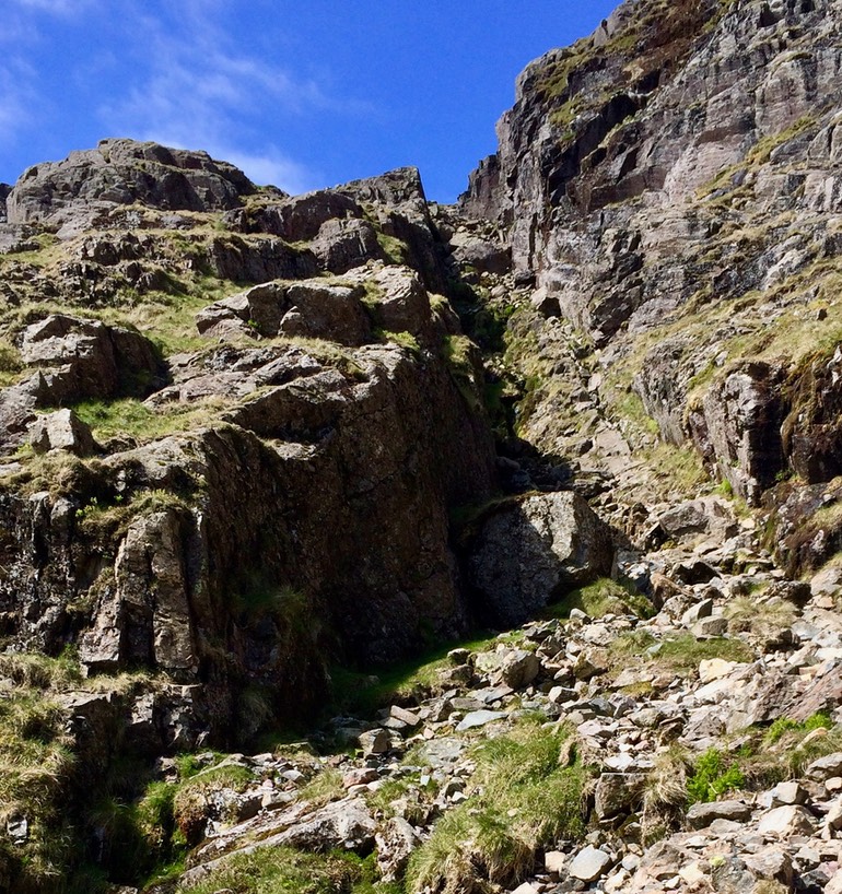
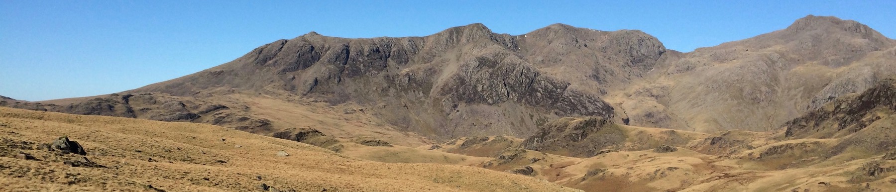
These two pictures are taken from the same low point between the two peaks, at about 630m —where the skyline on the left is the ridge of Mickledore at 850m. The camera is angled so as to show the view and so it may fail to emphasise how very steep this looks when there yourself. If you think the left pic looks steep, please believe that the gully to the right is even steeper.
Most would tackle this walk by starting from the head end of Wast Water. Most go up Lingmell Gill via Brown Tongue to Mickledore, which is the short section of ridge between the two named peaks. Many take a fork a little to the north and so don't see Mickledore and the expanse of Broad Stand. It is seeing this for the first time that makes one appreciate that to go up (or down) Broad Stand is a proper climb requiring equipment and skills that walkers usually lack. Again, most reaching Mickleden turn left and go to the Pike summit — and the few who wish to also do the Fell find a way between the two, which I show above.1 Once you have been to the Pike, it takes significant enthusiasm to contemplate the necessary descent on what is quite clearly the 'other' side from that previously climbed, then to be confronted with what looks like a wicked scramble (shown as the right-hand pic) offering only a vague promise of a successful ascent and access to the peak of the Fell, plus quite possibly returning this way. If I were contemplating this ascent, I'd do the Fell first by setting off more southerly from the head of Wast Water as if to Burnmoor Tarn, probably cut east beside Groove Gill and join the path to Sca Fell summit as it goes mostly east. Having 'bagged' the Fell, I'd take the descent as pictured (right down, left up) and climb to the Pike, followed by the prospect of the 'easy' path back to Wast Water. This makes a lot of sense. To me, at least.
Most of my many previous ascents of the Pike have been from Langstrath (Borrowdale) to the north or from Langdale to the east. I have been up Sca Fell only once before today (perhaps 1973) when I walked the whole ridge to the SE of Wast Water, reached the view of Mickledore and 'escaped' north to Wasdale Head. The Pike I have done at least twenty times, eight of which were the middle peak of the national set of three. I may have been up the Pike as many as thirty times; I have no real idea beyond it being 'many'.
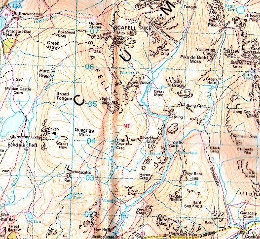
Last year I set off from home and shoved 'Seathwaite' into the satnav and just automatically confirmed selections and—it being very early–didn't take much notice where the satnav was taking me, simply trusting that it would pick the best route for the time of day. Silly twit; there is another Seathwaite, in the Duddon valley and north of Ulpha. What the satnav calls Seathwaite, Barrow, not Seathwaite, Keswick. Which Barrow Seathwaite is on the south side of Sca Fell Pike. So, being now forced to do sensible navigation and seeing few alternatives, I carried on north up the Duddon, reaching Cockley Beck, where the valley forks. This is the closest approach of any road to the Pike from this side; the Duddon valley continues (upwards, against the flow) toward Great Langdale and Wrynose, while the other branch is the Moasdale (on my map) and this fork of the road heads up to Hard Knott. The obvious choice of path from here for Sca Fell is to go up Mosedale. My map does not say Moasdale—though the 1:2500 names the river Moas not Mose—and I recognise there is another Mosedale going north from Wasdale Head, so there is even more potential confusion.
So, Sca Fell and Pike, from the south, recognised as possibly pretty stupid.
On a good day, meaning one with good visibility, Mosedale (Moasdale) presents a splendid vista of exciting things to climb, even for those who think English mountains are not worth the name. I add a pic from that day (20190226) here. The group of four are the only people I've ever met on this path.
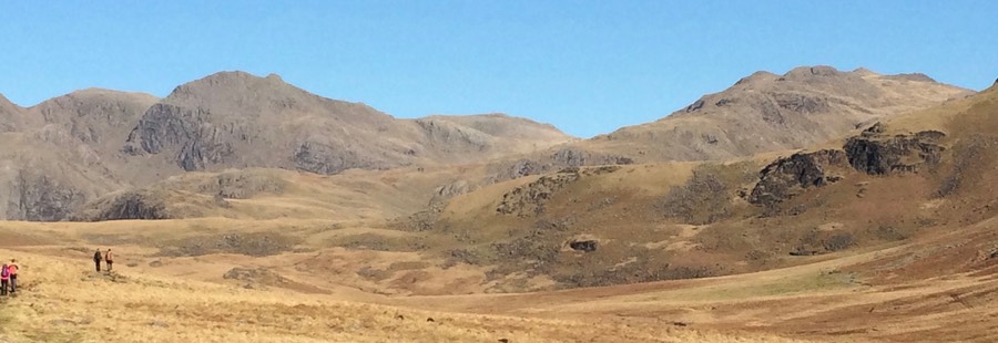
Me being me, I took the broad grassy slope just left of very centre of the picture—there's two hidden valleys in that view— crossing Lingcove Beck and the river Esk. From here there is a steep path (not Little Narrowcove but Howe Beck) taking one directly to Mickledore. This second landscape shows the Sca Fell pair. The short near vertical drop in the skyline (a quarter from the right edge) has Mickledore on the right, with the Pike on the extreme right and the Fell top right of centre.
Which is what I did on that occasion, returning much the same way, but on the NE side of Great Moss.
But, to do the pair—and having seen that horrible off-putting ascent to the Fell—I want to do the Fell first. And, I think, I will mostly come to that conclusion. 2 So, looking at the ground, that long lefthand ridge looks really attractive as a way up the Fell, even though all routes from here require two river crossings. So either I pack to accommodate suitably for wet feet or I wait for a long dry spell.
The route from Cockley Beck to the summit of ScaFell, as described and largely visible in the landscape above, took two and a half hours (07:30 to 10:00). The descent from ScaFell to the 630m point took a little longer than 30 minutes (I'm much slower downhill than I used to be), but the path is very visible from the summit. The grind to the pike and back to this 630m point is another hour, plus the 2-2.5 hours back makes the total walk seven hours. I wouldn't want to use most parts of this route in wet weather. The ascent to the Pike is a straightforward slog, with the worst bit the part shown near the top of this page. The return offers alternatives around Great Moss and (my 1:25000 map says, though I didn't see it) there is a bridge at the foot of Lingcove Beck, so one would still need to cross the Esk. I found neither of these any sort of problem yesterday. I recommend the north-south path beside the Esk that passes between the crags named Green and Throstlehow on my preferred may, but Silver Crag and Throstle Garth above (if the centre of the map is the centrre of a clock, then between four and five); picturesque.
A good day: I'll do versions of this again.
A challenge to which I have not risen, and probably now cannot, is to go up all of ScaFell Pike, Coniston Old Man and Helvellyn in the same day. These three used to each be the highest point in their respective county, so that would be Cumberland, Westmorland and North Yorkshire. I see at last how to go from the Pike to the Old Man, quite possibly through Cockley Beck; I've done the walk from Helvellyn to Sca Fell Pike already as part of a three-day tramp. Turning this into a full circuit without using extents of road is a very long walk; the ground is not nice enough to run it, so all in one day is a big task. Looking at feasible subsets of this I have done Grasmere - Helvellyn - Great Langdale in early January. I have regularly chickened out of doing the Pike and back to the New Dungeon Ghyll (NDG) in January, but I have done Seathwaite, both Gables and the corridor route and then descended to both Borrowdale and Langdale. So a feasible day in decent light would be from Langdale to the Pike, down to Cockley Beck, or the other way about. Cockley Beck to Coniston, possibly via Wetherlam, is on the to-do list as of today and I've done Coniston to Sail via the Old Man several times, even including that lovely ridge that includes Brown Pike and Dow Crag. But Wetherlam to Coniston would be best started from the top of Wrynose, which rather suggests that Crinkle Crags and Esk Pike should have been included in one's route from the Pike. That's both slow going and a very long day. So the challenge to work on is Cockley Beck to Coniston - it's only 5km for a crow - and then wonder if one could start from the NDG, cadge a lift to Cockley Beck and then do the Old Man and Wetherlam, crossing the top of Wrynose and Pike o'Blisco on the way back to the NDG. And do all that in time for a wash before one of their splendid dinners.
DJS 20190523
I've scanned the 1:50000 map to help a little. I note the several long southerly walks off to Eskdale (7km?, Boot village?), all of which strike me as paths rarely travelled. I spent part of a week camped (the tent stayed, I moved around a lot) in Green Hole just south of Bow Fell; we had permission to camp, which one needs when the camp is below 500m (or that was the rule at the time, 1600 feet). Probably 1970, doing Duke of Edinburgh assessment. Yes, I was still at school myself; no, I can't explain how I came to be in such a position, but I did feel competent.
1 Labouring this just a little: The route from Sca Fell sets off NE but soon curls around to the SE in a rapid descent. I never saw Foxes Tarn, where the path turns sharply back to the NE. The last part is pictured. From the low point of 630m one turns sharp left and takes the very obvious steep ascent to Mickledore. From there the path again to the NE is surprisingly easy to lose, given the volume of traffic it receives; you'll find a more obvious path by drifting left (northwards).
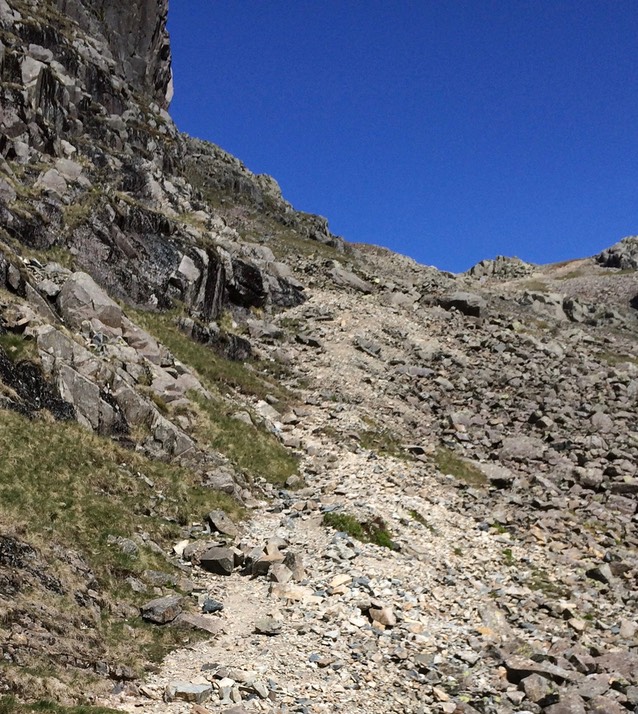
From the summit of the Pike, the obvious and visible path drifts to the right and, if visibility allows, take a bearing on the ridge of Mickledore before the 850m contour or you'll have to climb back up. The descent to the 630m point is not especially pleasant and could easily be hazardous in extreme weather. The gully climb as pictured is actually far more pleasant than it looks, but the subsequent apparently easy ascent is of much the same nature as that descent from 850 to 630 you already did and many will take to the few patches of grass in attempting to find better footing. I found that the finest gravel gave the best descent once one accepted that sliding would occur. For ascents, the fine gravel is fine if it is of little depth, otherwise I prefer to attempt to find horizontal surfaces on larger rocks. This route finishes in fine style to Symonds Knott and whichever of the several high points you decide is the 'proper' summit. For a route off, I'd do something different than the route already travelled, but that's just me.
2 This is largely because I dislike travelling ground twice. You can argue both cases here: To do both peaks and return to your starting point then it is likely that you're going to do an ascent of at least one of these and return along that route. So if there is choice, it is is between repeating the Pike or the Fell. In this case my preference would be to take the longer in-route and the shorter out-route. My reasoning is that my days are (now, with greater age) planned to permit opt-outs—when the fun stops, stop—and I no longer like committing myself to big chunks of walk late in the day, so I'd almost always opt for the lesser add-on. Which is what happened in February; it was about 1300 when I was at the foot of the gully to the Fell, with dark expected around 1600. It looked horrid, even with a couple on it at the top of what was visible and with another couple behind me intending to attempt it. My thinking at the time was that there was at least two hours walk off, plus an unknown time required for the ascent and descent to where i was standing. All of which meant I didn't have enough time before dark on a route new to me. So whatever my enthusiasm level, this was not a wise move.
So you see why in May, with far longer daylight, I still left home around 05:00 so as to start at 07:30, which would have put me at this critical decision point at around 10:00. Which in turn would reduce the decision to do both or not to enthusiasm and tiredness rather than deliberately heading into danger. Yes, it is apparently dangerous just getting out of bed, but there are risks we take deliberately and those we take carelessly. Now, having done this walk, I know that the Pike takes an hour from the 630m decision point and back to that place. I think the Fell can be done in about the same time from there, but perhaps only in decent weather. The choices of routes to your first of these two peaks is then a different decision set.